Introduction
Climate change and environmental pollution have become a global issue in the last two decades. To reciprocate the disastrous effects of human activities on the planet and living systems, it is our foremost duty to conserve wildlife and their habitats. Environmental monitoring has always been challenging and requires significant capital, particularly in remote and far-reaching areas.
The breakthrough in the drone market completely transforms the whole scenario. The advancements in this field are a result of efforts from the past ten years Mwaura, n.d.). To protect and conserve wildlife habitats, it is necessary to have data on their behaviors, numbers, and living habits. The historical methods of gathering this information, i.e., manual and aerial surveys, are challenging and expensive, particularly in dense forests and mountainous terrains. Unmanned aerial vehicles (UAVs) have simplified this task. They facilitate the process of data collection and processing by providing high-end images, which cover areas of land and sea in less time than usual (edrazzi et al., 2025).
This article provides insights into the role of drone technology in environmental science and conservation. It will explain how drones are used in these areas of science, including how we track animals and their movements and gather and analyze data. We will also discuss their implications and future possibilities.
Evolution of drones
Drones are remotely operated or autonomous aerial vehicles with advanced sensors and cameras. These unmanned aerial vehicles have previously been used solely for military purposes; however, due to the technological boom, they are now finding applications in environmental conservation and monitoring. They have access to remote areas and cover vast areas more quickly compared to traditional methods Corcoran et al., 2021).
In 2024, a study made a remarkable breakthrough by combining Convolutional Neural Networks (CNN) with a support vector machine (SVM) deep learning model, which achieved 96.02% accuracy in identifying almost all types of wildlife species (Kaur et al., 2024). Machine learning is rapidly transforming drone technology, with a recent advancement that utilizes a combination of CNN and LSTM to achieve accurate species classification. This system has an accuracy rate of 96.44% (Dadial and Thakur 2024).
READ MORE: WHY WOMEN AND CHILDREN SUFFER THE MOST FROM CLIMATE DISASTERS?
Drones for wildlife conservation
Population and behavior surveillance
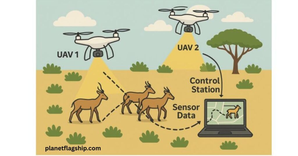
Drones enable wildlife census and surveys without disturbing the animals. They can reach inaccessible areas and gather information that cannot be otherwise possible with a ground crew. They also aid in the monitoring of species’ behavior by recording videos. For instance, WildWing generates 4K videos of animals like zebras and giraffes, thus allowing for their autonomous behavioral analysis. This is an open-source unmanned aerial system (UAS) that facilitates continuous and automatic data collection of herds to study their social interactions Kline et al., 2025).
Another example illustrates how drones have evolved to aid in locating rare species. A study was conducted in Vietnam in 2022 to find Swinhoe’s softshell turtle. The researchers investigated Dong Mo Lake and successfully found one of three giant turtles by drone photographs (newsroom.wcs.org). Additionally, UAVs are also used for health monitoring and collecting samples of DNA and microbes from animals’ exhalations. SnotBots are used for this purpose to take samples for critically endangered species (weforum.org). Tagged animals are monitored, and thermal sensors are used in drones to track animals in rainforests. According to reports from UNICEF and UNEP, UAS can track living organisms in a matter of minutes, transforming the science of animal tracking and conservation.
Combating poaching activities
One of the most distinguished applications of drones is their use in monitoring poaching activities in protected areas. Such drones use infrared cameras that hover over the designated areas and indicate the location of hunters and injured animals as well. They permit patrolling forces to monitor dense areas and difficult terrains without leaving their office spaces.
These types of drones are working efficiently in Kruger National Park, South Africa, where they have caught more than 50 poachers in their first month of operation. Studies also reveal that infrared sensors can accurately locate animals, such as rhinos, even in complete darkness. Recent advancements have resulted in the deployment of AI algorithms and GPS to track the movement of wild animals and their locations, respectively. Now, drones can also transmit real-time data and imagery. These devices are actively used in Asia and Africa to fight against the increased poaching threats to rhinos and other wild animals. However, conservationists face some constraints in these areas regarding regulations.
Mapping and monitoring of forests and vegetation
Drones are now playing a crucial role in defining habitat structures and mapping vegetation in the world’s large forests. They have found vast applications in tropical forests, providing canopy structures as well as tracking deforestation and reforestation progress at very fine scales. In Madagascar, UAVs were used to fight illegal logging activities. They utilized drone-generated images to identify areas of high logging and alleviate the burden on regulatory organizations. Drones now produce clearer photographs than satellite imagery, which helps in calculating carbon credits and forest volume Williams, 2024).
Drones are used for studying post-fire impacts, calculating biomass, and generating a directory of tree species. According to the USDA, drones can be deployed as needed to collect information and create time-lapse videos of tree growth and forest cover density. Drones have various applications in temperate and boreal regions, providing high-end data. They use multispectral cameras and issue warnings about pest attacks beforehand West, 2023).
UAVs in coastal and marine systems
Drones have become indispensable for monitoring aquatic systems. They evaluate habitat conditions in coastal areas, thereby aiding in effective surveillance. Drones combine visual data with deep learning models and calculate the extent of coral bleaching and other factors over large areas. They can evaluate sea surface species as well as measure surface temperatures by using heat-sensitive cameras. Thus, drones are very effective in studying aquatic ecosystems, such as mangroves, corals, and seagrasses Mahdavi et al., 2024).
UNEP reveals that UAVs have wide-ranging applications, from their use in restoration efforts, such as dropping seeds in remote and hazardous terrains, to monitoring pollution levels along shorelines.
Landscape change and Land-use planning
Over the last few decades, the landscape has undergone rapid changes, and drones are now actively used to inform planning. Drones can effectively portray corridors and vulnerable habitats, especially in high-biodiversity regions. LiDAR technology, along with remote sensing techniques, is used in these areas to monitor land-use and land-cover changes. Some examples of drone use in this field are;
- Mapping of alpine meadows
- Surveillance of birds and their nesting habits in wetland areas
- Mapping of flood-prone areas to help in proactive management.
- UNEP and Global Forest Watch are using a mix of drones and satellites to monitor deforestation and contamination
Drones for Environmental Monitoring
Pollution and Environmental Monitoring
Aerial drone technology is now transforming environmental and pollution monitoring systems. They are being used in observing aquatic and terrestrial systems.
- NOAA utilizes unmanned aerial vehicles (UAVs) to detect the location and thickness of oil spills, thereby aiding surveillance and rescue teams in quickly reaching the affected areas.
- In industrial zones, these aerial vehicles are used to detect the areas of methane leakages.
- Japan is using gas sensors with them to measure the amount of GHGs in different localities.
- Along the coastal areas, drones are used to spot heaps of waste and utilize metal sensors to locate lost fishing nets.
- Drones have become invaluable in gathering water samples for detecting quality parameters and for studying changes before and after in samples from affected areas.
- Precision farming is significantly enhanced with the employment of drones. They can accurately detect soil moisture and optimize fertilizer application.
Climate and weather monitoring
Uncrewed surface and aerial vehicles are used to collect real-time climate data. NOAA and other international organizations are using drones for weather predictions. The Intergovernmental Panel on Climate Change (IPCC) has also emphasized the use of drones for forecasting purposes. NOAA is using a specialized type of drone named SailDrone to measure the speed, height, and pressure of hurricanes. While determining oceanic atmospheric conditions and predicting the intensity of upcoming typhoons, they can also provide valuable data for research.
Japan has developed drones that can go to the polar regions. They navigate these terrains to transmit data. Aerosol counting systems are also deployed in these drones, allowing them to study and measure temperature, humidity, and types of clouds. In the Arctic region, these aerial systems can be utilized for polar meteorology, including measurements of icing and de-icing speeds, as well as albedo changes.
Disaster Assessment and Management
Drones have become very important in rapid human response to disasters. They can easily reach and capture damaged areas, providing data to the rescue teams.
- In 2019, when a cyclone hit Mozambique and caused massive destruction, UNWFP used drones to observe the flooded residential and agricultural lands. They produce orthorectified maps, which are used in combination with GIS systems to facilitate rescue operations.
- During the 2020 California fires, swarms of drones equipped with infrared cameras were used by firefighting and other agencies to measure fire intensity, identify hotspot areas, and determine boundaries. Firefighters then used these maps to save human lives and properties.
- In the case of the 2023 Turkey-Syria Earthquakes, drones are employed to find people under the rubble. Drones can provide high-end images, insights into topography, and other relevant data.
Critical Reflections and Future Considerations:
The analysis of various case studies and a literature review demonstrates that drones are cost-effective and have wide applications in wildlife conservation and environmental monitoring. The major advantages include the provision of high-resolution images, the use of various sensors, thermal imaging, access to hazardous areas, and reduced human involvement. UAVs can also aid in studying macro and micro habitats and filling the gaps between satellite and ground data collection.
Nevertheless, drones are not a solution to all problems. They have limitations as well, including a limited battery and flight time, which restricts their area coverage. Bad weather can also limit their operations. Small-sized UAVs can fly for a limited time and may cover approximately 5 to 10 km. Sometimes, drones produce large volumes of data, and to process such data and metadata, high-end software is required. Some countries have strict regulations regarding the flight of conservation drones, especially in Africa. The requirement for permits also slows down the whole process. Such limitations also result in unequal distribution of resources and lead to biased conservation decisions. Following are a few recommendations for future drone usage;
- Employ artificial intelligence in combination with machine learning models, which can automate images and behavioral data and reduce the need for manual analysis.
- International bodies should open-source databases of conservation drones to train AI-based aerial vehicles efficiently.
- To increase the flight time of drones, solar cells can be utilized, and advanced sensors, such as acoustic sensors, can also expand their applications. For instance, CW-25 drones have already made up to 10 hours of flight capability.
- Efforts should be made to establish universal guidelines for the use of drones for research and conservation purposes. Governments should also train local communities and NGO members to pilot these drones.
Frequently Asked Questions
How exactly do drones help protect endangered wildlife?
Drones monitor wildlife populations from above without disturbing them. They help track rare species, observe animal behavior. It detects poachers with infrared cameras making conservation smarter, faster, and safer.
Can drones really detect pollution or monitor climate change?
Yes. Drones are filling with gas, heat, and chemical sensors can locate methane leaks, oil spills, plastic waste. It tracks hurricane pressure giving scientists critical, real-time data to monitor climate and pollution.
What makes drones better than traditional wildlife monitoring methods?
Drones can reach remote or dangerous locations with ease, gather high-resolution images, and cover huge areas in less time. They reduce human disturbance and capture consistent data.
Are drones being used in ocean and marine conservation too?
Yes! Drones fly over coral reefs, mangroves, and coastlines to monitor bleaching, map seagrass. It collects sea surface temperature readings helping researchers study and protect fragile marine ecosystems.
What are the main limitations of using drones in conservation?
Drones are game-changers, they face challenges like short flight times, weather dependency, regulatory restrictions, and data overload. But with better batteries, AI, and policy reforms, the sky’s the limit.
Conclusion
In conclusion, drones have undergone significant development from experimental gear to primary resources. They have wide applications, ranging from monitoring coral reefs to sampling the microbiomes of underwater species, from collecting image data to generating heat maps, and from monitoring polar regions to supporting anti-poaching efforts. Sustained technological advancements, including automatic systems, advanced artificial intelligence, sensors, and deep learning and machine learning models, will further increase their use in conservation science.
Drones are a solution to many long-standing problems by providing valuable insights into conservation efforts and climate impact assessments. Efficient use of drones is only possible by taking into account ethical considerations and community engagement. Hybrid systems that leverage space satellites, historical techniques, and drones can improve field applications. Future directions involve organizing training programs for drone pilots, developing policies for data and community privacy, and fostering collaboration between personnel from different fields.
References
Corcoran, E., Denman, S., & Hamilton, G. (2021). Evaluating new technology for biodiversity monitoring: Are drone surveys biased? Ecology and Evolution, 11(11), 6649–6656. https://doi.org/10.1002/ece3.7518
Kline, J., Zhong, A., Irizarry, K., Stewart, C. V., Stewart, C., Rubenstein, D. I., & Berger-Wolf, T. (2025). WildWing: An open-source, autonomous and affordable UAS for animal behaviour video monitoring. Methods in Ecology and Evolution. https://doi.org/10.1111/2041-210X.70018
Mahdavi, S., Amani, M., Parsian, S., MacDonald, C., Teasdale, M., So, J., Zhang, F., & Gullage, M. (2024). A Combination of Remote Sensing Datasets for Coastal Marine Habitat Mapping Using Random Forest Algorithm in Pistolet Bay, Canada. Remote Sensing, 16(14). https://doi.org/10.3390/rs16142654
Mwaura, M. (n.d.). The Use of Drones in Environmental Monitoring and Conservation. https://rijournals.com/biological-and-applied-science/
Pedrazzi, L., Naik, H., Sandbrook, C., Lurgi, M., Fürtbauer, I., & King, A. J. (2025). Advancing animal behaviour research using drone technology. In Animal Behaviour (Vol. 222). Academic Press. https://doi.org/10.1016/j.anbehav.2025.123147
West, A. (n.d.). Eyes in the Sky: Using drones for forest monitoring Science You Can Use Bulletin Forest Service.
Williams, J. (2024). UAV survey mapping of illegal deforestation in Madagascar. Plants People Planet. https://doi.org/10.1002/ppp3.10533
Dadial, R., & Thakur, B. (2024). Advancing Wildlife Conservation through Drone- Based Multi-Classification of Species with Fused CNN-LSTM Deep Learning Model. 2024 10th International Conference on Advanced Computing and Communication Systems (ICACCS), 1, 1317-1321.
Kaur, A., Kukreja, V., Chattopadhyay, S., Verma, A., & Sharma, R. (2024). Empowering Wildlife Conservation with a Fused CNN-SVM Deep Learning Model for Multi-Classification Using Drone-Based Imagery. 2024 IEEE International Conference on Interdisciplinary Approaches in Technology and Management for Social Innovation (IATMSI), 2, 1-4.

John is a professional blogger and passionate advocate for environmental sustainability. With years of experience exploring eco-friendly practices and green innovations, he shares insightful articles on Planet Flagship to inspire a sustainable future. John’s expertise lies in making complex environmental topics accessible and actionable, empowering readers to make meaningful changes for the planet.